My Trip to Telema’n
I seldom write a journal but decided to on my first trip with the Nature Defenders of Guatemala to visit a planting site. Here is what I wrote.
So here I am after a grueling 7 1/2 hours driving. (four on good highways and three on a dirt goat trail). I am at the Nature Defenders office in Telema’n. Telema’n is located to the north and east of Guatemala City, but on the north side of the mountain range Sierra de las Minas. We are located about 80 km west of Lago Isabela for those of you that have a map of Guatemala. I step out of the vehicle into what feels like an oven, perhaps in the high thirties. We are at an elevation of about 100 meters above sea level. Coming out of an air-conditioned vehicle, the air feels stifling hot and more humid than in the city. The smell of pigs is in the air. The woman in the tienda across the street is throwing water on the road to cut the dust. I take a picture or two of her and picture of the Nature Defenders sign and posters saying “Cuidado”, be careful with fire and “Salvemos Nuestros Bosques” Save our Forests.
The trip here was brutal with the Polochic road off the main highway composed of dust, rock and pot holes (like the first 15 km of the South Castle road, but worse). From a height of land at 1500 meters to this town at 100m there is a significant change in ground cover from conifer and deciduous forest to deciduous evergreens to grazing land to sugarcane fields. The sugar cane is new and its incursion into the area is a sign of improvements to come.
La Tinta, located 14 km to the west, looks like a decent little pueblo but with a dirt road in and out, I would not choose to live there. Driving through the town is nice because of the brick road.
Guatemala is beautiful outside of the city.
Now I am at the restaurant with the director of the Nature Defenders. I am faced with beef, chicken or soup. We are at the Texaco restaurant and there is a lot of beer being served. Outside, the local taxies are gassing up. They are old pickups (usually Toyotas) that have a metal cage attached that allows for lots of people to hang on. How many people can fit in one vehicle?……..Just one more is the correct answer. I saw a Toyota pickup with perhaps 40 people standing in the back. Three were standing on the back bumper as the front end of the vehicle swayed nearly out of control down the road. Everyone was laughing and having a blast. Oh, I ordered chicken because it looked like it was cooked in the oven. I would not trust the soup because of the uncertainty of the water and of course coming from Alberta have no interest in the shoe leather beef served here.
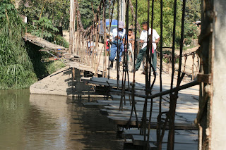
Back to the Nature Defenders office and to the area director’s house. We change vehicles and head out. Lots of dust, and here is the big river (Polochic) and the crossing. I gulp.. it is a narrow cable bridge and all the locals head off the bridge as we drive onto it. It is as if they are expecting it to collapse and want a good view. We stop half way over because the driver has to adjust the planks ahead. I take a close look at the planks, but they are not planks they are slabs from a saw mill. Not nailed together and there are not enough of them so the driver is going to distribute them so we can cross. I look at the two, one and a half inch cables, feel the swaying, look down at the deep water and I decide to walk to the other side and manage one picture before the truck makes it across. A new bridge is being constructed down stream and not too soon I can assure you! This old bridge was constructed in 1960 and is an accident waiting to happen. Off we go through the first crop of sugar cane. We are now at Old Village River (Pueblo Viejo). It is about the size of the Flathead River near the BC/US border during the low water season in late fall. Good potential to be much higher and faster during the rainy season. We approach the ford and I see that the water is crystal clear like the South or West Castle rivers of southern Alberta (when the cows are not wading in it). We complete the ford and travel through cattle land and a large latex forest. That is to say, there are many hectares of old trees all being farmed for sap used in the process of making latex. It is similar to maple sugar harvests I think. The latex finca (plantation) is large. All the trees have a quarter inch tube and a small metal bowl strapped below to capture the sap.
We come to another nice river about the size of the Castle River in late August at the rodeo grounds. This river is also crystal clear with bigger rocks, indicating some rapid movement during high water. If I am to transport planters into this area, this could be a big problem! Apparently the first river we forded has 16 communities along it and this one has 12, but it is obvious that they must be located somewhat away from the river because the pollution, if any, is not obvious like most of the other rivers I have seen in Guatemala. Both of these rivers come out of the Sierra de los Mines protected area where we will be planting..
We start up on an eroded road, bump, bump, up, up, bump, we contour our way past trees and corn crops. I think we are near the end of the world. We stop and take pictures of a recent PINFOR plantation. I take a leak and jump back into the truck. We round the next corner and there is a soccer field with a dozen players. Up and around the next corner, and whoa, a pueblo. There are tinned roofs with a makeshift market in the centre and stores all around it. Very poor, that is obvious. I am thinking that tree planting here will provide some needed work and funds. We stop and get out to meet the local forest ranger (just a mean looking guy with a machete). I point my camera at some kids and they all run and hide. They start peeking around the corner, I point, and again they hide. The place is very poor with chickens and pigs running around freely and some very malnourished dogs. Up another 200 meters we go and below us is a nice soccer field, basketball court and a school. These are real mountain people. Wait, am I hearing banjos??? No just joking. Anyway, we get out and begin walking up the hill through the yards of many people, around sleeping pigs etc. I see barren houses with tin or thatched roofs. We stop and look down a steep ravine, perhaps it is 70 meters across with the sides steep to 70% slopes. They want us to plant this hell hole and explain that the PINFOR reforestation is a subsidy program intended to help reforest these difficult spots. I point to two faces and say okay, but the north facing slope is very steep with lots of wicked brush, worse than devil’s club. I take a machete from the ranger and cut one branch off. It falls onto my arm and I start bleeding. I say “esta es malo”. Which might mean “this is bad” if I have it right. I tell them that there is no way we can plant this hectare as a first planting site and ask if we can view the next site. They point to an area about 300 meters up and across this gorge. We walk further up the trail to the location. I am relieved to see that this piece of ground is 75% corn crop on about 25 to 30 % slope, all cultivated except for one side. Okay, I say, we can plant this site. They will prepare the site and stake the location for all the seedlings. We head back and I take pictures of the native landowner’s family and promise to bring them copies. It is dark when we get back to Telema’n and we are locked into a motel. The roof is very hot and stays that way all night. The food is okay, but there are so many sparrows flying around this third floor restaurant that it cannot be clean. At breakfast, part of a bird’s nest falls onto my plate. I am not that hungry! We travel back to the city and continuing planning for the first planting for the Trees for Global Renewal Project.

